 Intermediate
Fun shallow natural waterpark.
Location
https://maps.google.com/maps?q=Locust+B ... 8&t=h&z=18
Coordinates:
48.772642,-122.532535
Directions:
- About 20 minutes south of the border on I5
- Exit 258
- Right on Airport Drive
- Then immediate left on Bennett (at the am/pm)
- Continue south on Bennett
- Right on McAlpine
- Left on Locust Avenue cross Marine Drive
- Turn right into the second driveway which is the NSKA clubhouse
Parking:
- Public parking lot at the on northwest corner of Marine and Locust Avenue at the NSKA clubhouse (better than parking on the road). Fastest option (no turning around)!
- South side (outbound) side of the road as the signs show. Its sloped and often muddy, but shorter walk for windsurfing gear. If you park on the road make sure to park in the direction of travel with tires off the pavement (it sounds like the both tickets add up to over $300).
Seasons/Days/Strength:
- Wind can be much stronger than other sites to the north
- More wind more often than Centennial
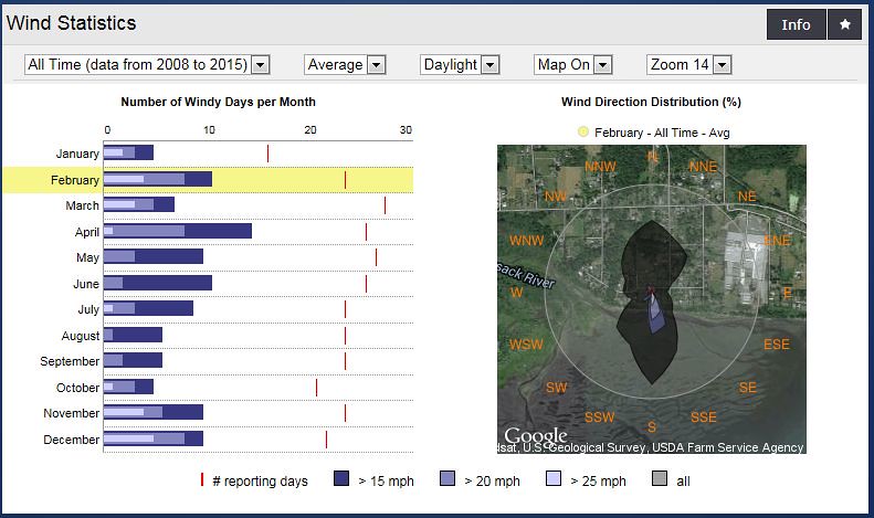
- 12 months have 20 mph days
- 8 months of the year have 25 mph days including April, July and October (warmer)
- Spring (Jan, Feb, Mar) and fall (Oct, Nov, Dec) are fairly balanced (number of days and number of strong days)
- Stronger showing in than Centennial in the late summer through the early fall
- In the late spring and early summer locust tends to blow in the morning. Usually starting around 7:00 AM and lasting for a couple of hours. If its blowing at locust and you see a fog bank it will last longer.
- It can often blow stronger and longer on the days it switches from a North wind to a South wind. You can use the North Sound NOAA forecast on the BKB wind page to see what days the wind is predicted to switch directions (typically you'll see the wind speed is highest for these days).
- April has the most days, but February, November and December show more days over 25 mph
- South wind dominates (the north wind may be over stated as the sensor was misreading direction for a while)
- Southeast through southwest (but south is smoothest).
- Hunter Beach is often great on the north wind days when it is hot and sunny, but check the tide because if it is much lower than +4 feet it is a really long walk. Low tide days, go to Dogfish instead (deeper water, more side on at times). Hunter/DF fire in the afternoon (this is Samish Bay so use that sensor to check).
- Wind can be volatile – up, down and back up again
- Southeast can be shifty causing a wind shadow along the beach with much stronger wind out in the bay
Conditions:
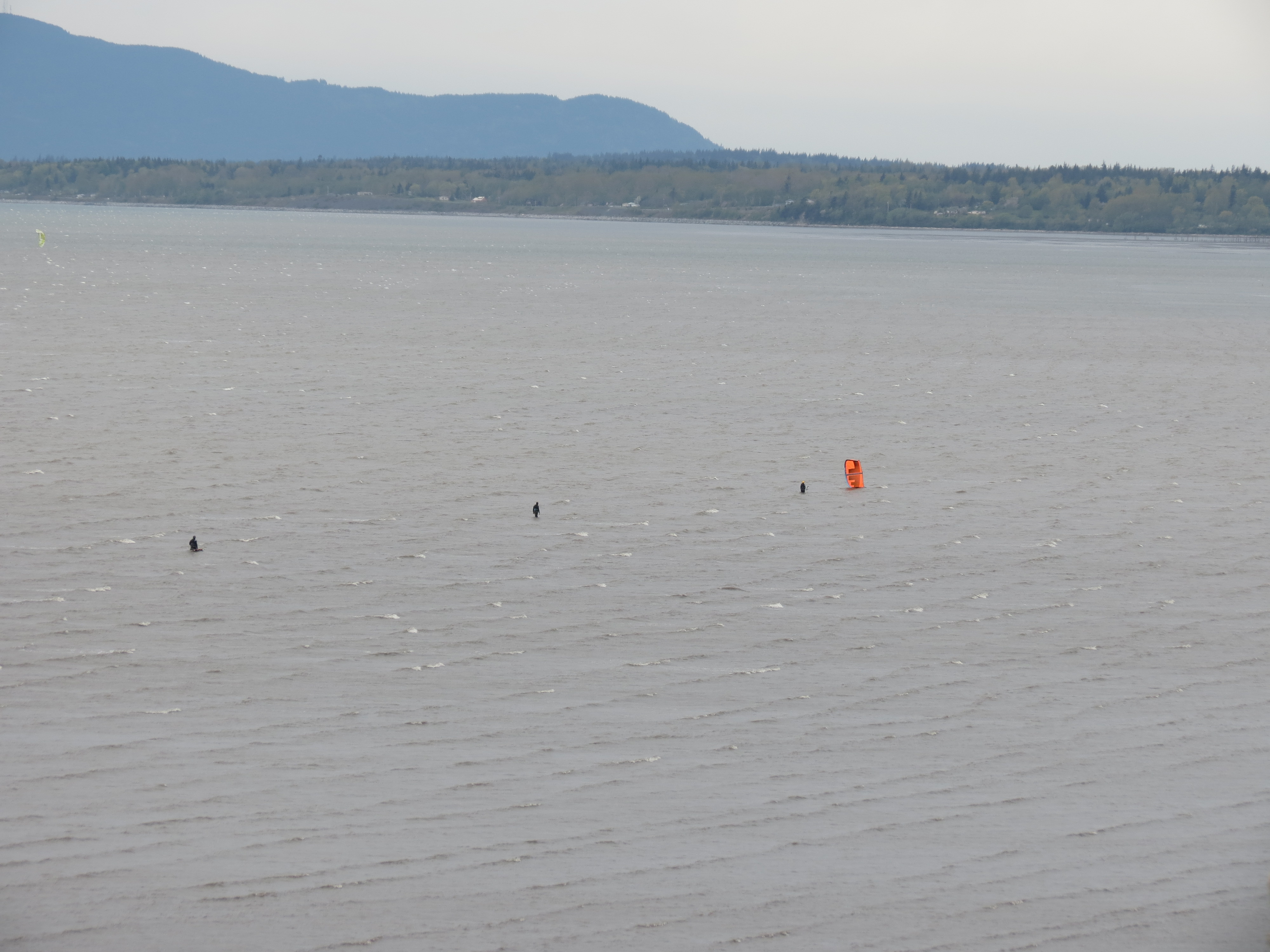
- Small chop at the launch increasing in size to the south and eventually turning into a rolling swell in the deeper water.
- Waist to chest-high semi organized waves on stronger wind days with higher tide (over 7’).
- Ramps in both directions with port often favoured
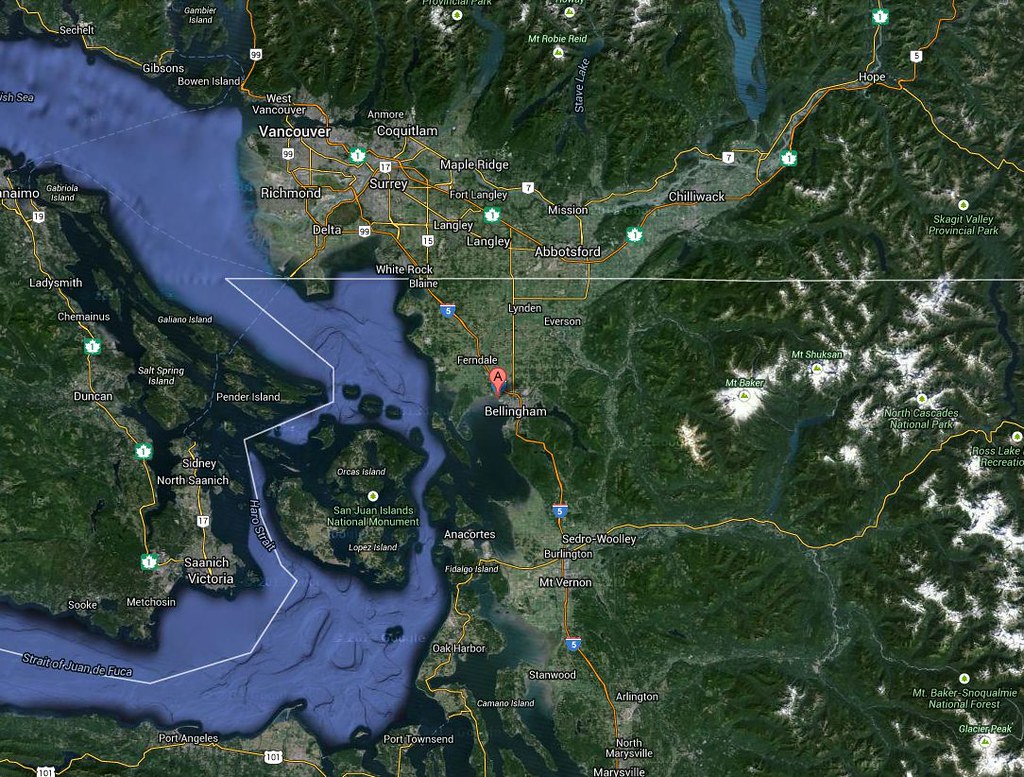
The bay is about 8 km wide (about four times the width of Howe Sound at Squamish, so there is lots of open water.
Depth/Tide:
It is possible to sail at Locust on any tide height – it’s just a matter of how far you will have to walk to reach the water.
- 0’ - VERY long walk
- 3’ - LONG walk to the south - dry bench at the launch (one of the locals mentioned if the tide is below 4' Post Point is a great option for windsurfing with 'waves')
- 5’ - Knee high water (5 min walk) - dry bench north of the launch along the north shore
- 7’ - Chest Deep water - knee deep water at beach
- 9’ - Shoulder deep water - waist deep at the shore
- 11’+ - Overhead high water - chest deep at the shore
Sweet Spot(s):
- Shore break at the launch on higher tides
- Point to the base of cement plant pier
- Ship wreck (southwest of the launch)
What to Wear:
- Winter: 6/5/3 full suit with hood, boots, gloves
- Spring/fall: 5/3 full suit, hoods, boots
- Summer: 3/3 full suit or less
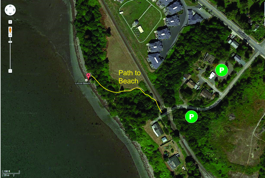
Walk to the end of Locust Avenue, under the railway bridge, turn right on the path, down the stairs to the beach.
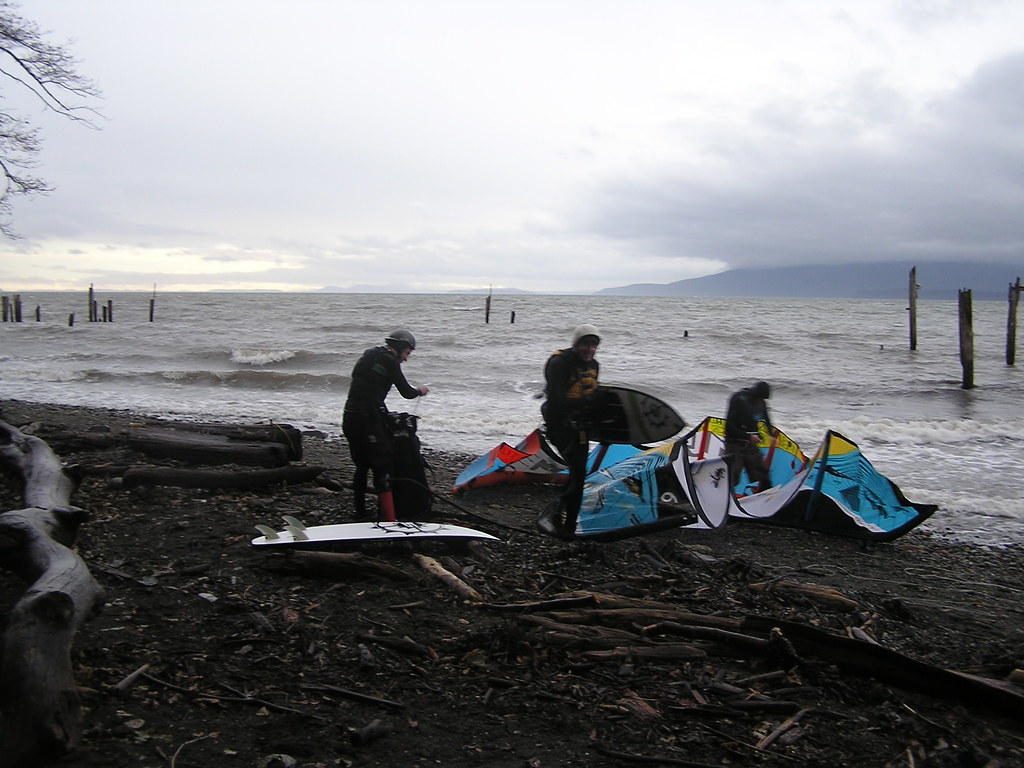
Rigging Area:
- Smooth rocks at high tide, sand at low tide.
- The beach space is minimum when launching above 7 ft. tide. However with a couple of helpers, it is do able as long as there are no weeds. Landing above 7 ft. means you have to drop your kite accurately into the catchers hands as you drift in. Any higher, just flag out and wind up off shore and swim in.
- NSKA manages the parking lot, community center and porta potty outside the center. The community center has a door combo and is reserved for NSKA members only.
- No fees for parking or launching fee, but donations are appreciated..
- The drop box is set up in the parking lot for memberships or donations but there is no parking or day use fee. Donations go toward the NSKA general fund which supports wind sensor porta potty, and building maintenance as well as efforts to open and maintain launches in the surrounding area (ie Hunter).
- Leave a few bucks in the yellow parking fee box for good karma and to ensure good winds.
- NSKA annual membership can be purchased at http://www.nskite.com/
- There are some nice restaurants in old part of downtown Bellingham (south on Marine Drive) and in Fairhaven (further south).
Cautions:
- Beach is a long walk of over 200 metres from the parking lot
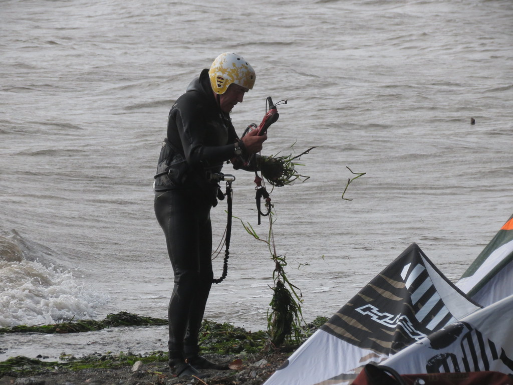
- Lots of debris in the water is common (discharge from the river following after heavy rain).
- Trees overhang the beach (tricky for kites on higher tides).
- Parking on street can shorten your walk if you are carrying windsurfing gear.
- Click here to watch a short video on how to carry your windsurfing gear "Hawaiian style" (thanks to "Leopard Skin" for posting).
When to go:
- SE forecast that looks doubtful at Centennial
- Check TJ’s zoom the night before
- Actuals on the sensor are gusting over 25
- The East Sound - Arlington gradient (second from the bottom) is S and over 0.10 (good, solid mid range wind)
0.06 is big kite gear/foil wind (sub 15 mph)
0.08 is 12 m kites (15-20 mph)
0.10 is good, solid mid range wind (20+ mph)
0.12+ is rocking down there
0.17 is NUK'N baby!
Bellingham Bay navigation chart
Bellingham tide
sensors - Bellingham Kiteboarding wind page
sensor - Locust West
sensor - Se’lhaem - Bellingham Bay Bouy
six hour rain and snow forecast
webcam - Birch Bay
webcam - Bellingham Bay
webcam - Post Point
border crossing wait times
Pictures and Videos
Unless noted otherwise, all pictures used and referenced in this post are by C36 (all rights reserved).
Locust Beach orientation
Locust drone video
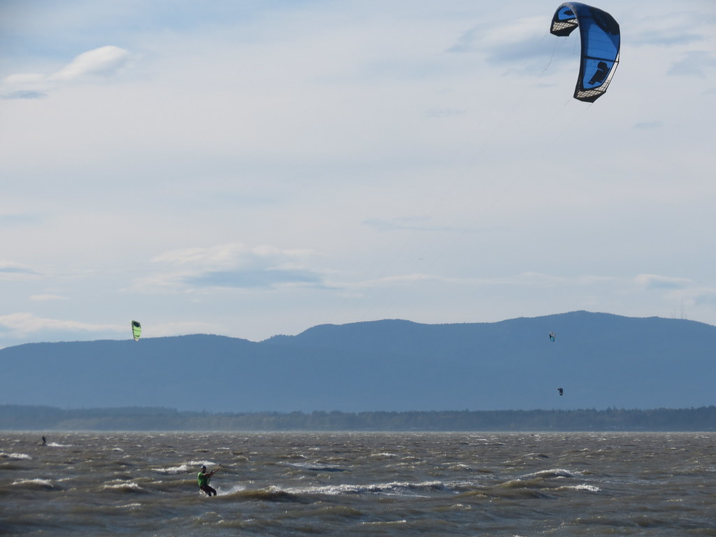
South 20-25 mph on 8' tide (2015 Feb 1) - 110/5.3/23
South 20-30 mph on 6'+ tide (2014 Oct 28) - 92 Quad/4.5
South-southeast 25-40 mph on 6-8' tide (2014 Oct 19) - 110/5.2/23, 92 Quad/4.0
South 30-35 mph on 7' tide that dropped to 4' later (2015 Jan 23) - 92 Quad/4.0
Birch Bay WNW 30-35 mph (2019 April 4)
Other Stuff
First Discovered By: ?
Lore and Legend:
One theory as to why Locust get so much more wind is its position on the elbow of the Salish Sea combined with hills/mountains on either side which form a natural narrowing or venturi concentrating the wind.
Source: Google Maps
Disclaimer
Every sailor is responsible for sailing safely, including checking local conditions first hand, choosing appropriate gear and sailing within their ability.
Thanks
Thanks to Alton, Chuck, Jerry, and Shad for sharing their knowledge. The NSKA and the local shop in Bellingham are a great group of people who are very supportive and welcoming...nice to support them both.
Updates
If you see anything that should be corrected or you have information that you think should be added, please post it to this thread and we will update the main post. Thanks.
/edit (2015 Feb 23): Natural venturi theory and picture added to "Lore and Legend" section.
/edit (2015 Feb 25): Link to carrying your windsurfing gear video added to "Tips" section.
/edit (2015 Feb 26): Links added to navigation chart for Bellingham Bay in "Tides" and "Links" sections (thanks Lowesdown)
/edit (2015 Mar 29) - reference to using Post Point for windsurfing launch below 4' added to the "Tide" section
/edit (2015 Apr 13) - links to photos added for 0', 3', and 5' in the "Tide" section
/edit (2015 Apr 29) - link to Bellingham Bay webcam added to the "Links" section
/edit (2015 Dec 12) - link added for Six Hour Rain and Snow Forecast
/edit (2016 Feb 22) - link added for Se’lhaem - Bellingham Bay Bouy and East Sound - Arlington pressure gradient
/edit (2016 May 14) - link added for Post Point webcam
/edit (2016 May 25) - summer wind info added and info added for Hunter/Dog Fish (thanks to Daniel and Andy)
/edit (2017 Mar 24) - link updated for East Sound - Arlington pressure gradient
/edit (2017 Apr 25) - link to Post Point webcam updated
/edit (2017 May 24) - link added to Locust drone video
/edit (2017 Sept 14) - link added for Birch Bay webcam
/edit (2019 April 29) - link to Birch Bay video added
/edit (2019 Aug 15) - link to Bellingham Kiteboarding wind page added
