Nexen offers a family-friendly alternative to the Squamish Spit with sandy beach for the kids, several walking/biking trails that connect to the marina brewpub area which is within two blocks of downtown (lots of shops and restaurants). The only downside is when it is windy enough to sail it is windy on shore at the beach. But you only have to go a couple hundred metres down the trails to escape the wind.
 Beginner
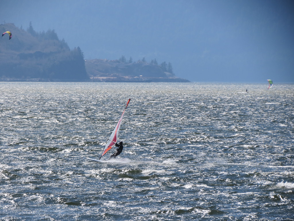
Protected cove with shallow flat-water summer thermals.

 Intermediate
Open water bump and jump summer thermals!

Location
Coordinates:
49.684482, -123.163951
Directions:
- Take Highway 99 to Squamish
- Turn onto Cleveland Avenue and travel south
- Turn left on Vancouver Avenue
- Turn right onto Logger’s Lane
- Follow Loggers’ Lane (Galbraith Avenue) to Nexen Beach

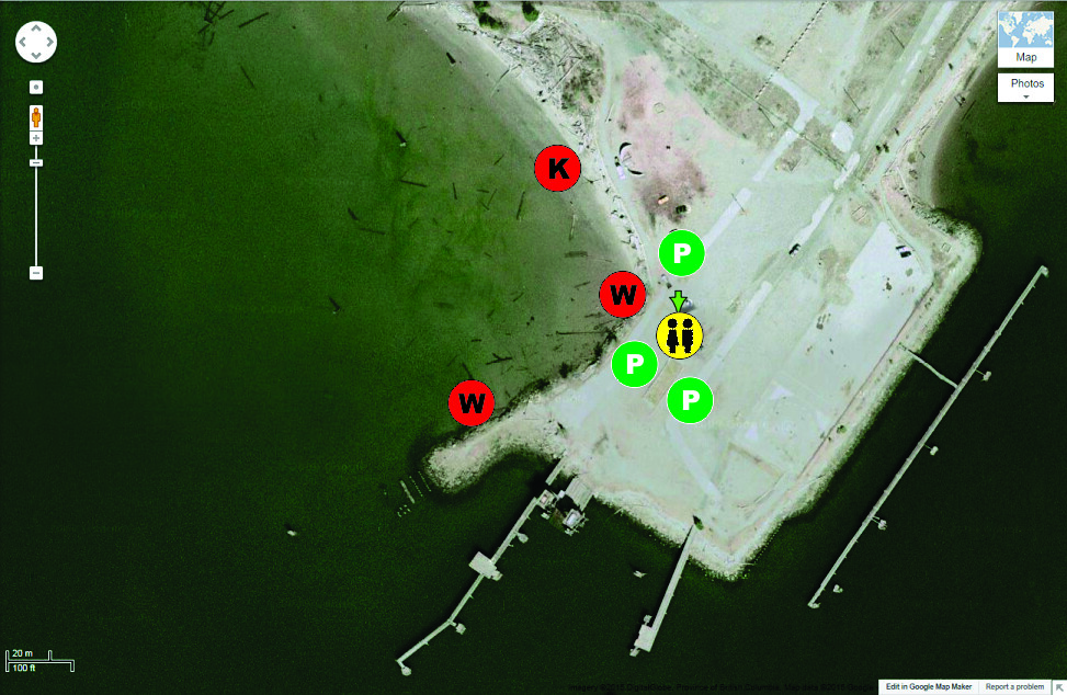
Parking:
- Kiters tend to park close to the cove
- Windsurfers tend to park close to the point on either side of the enclosed grass rigging area
Wind
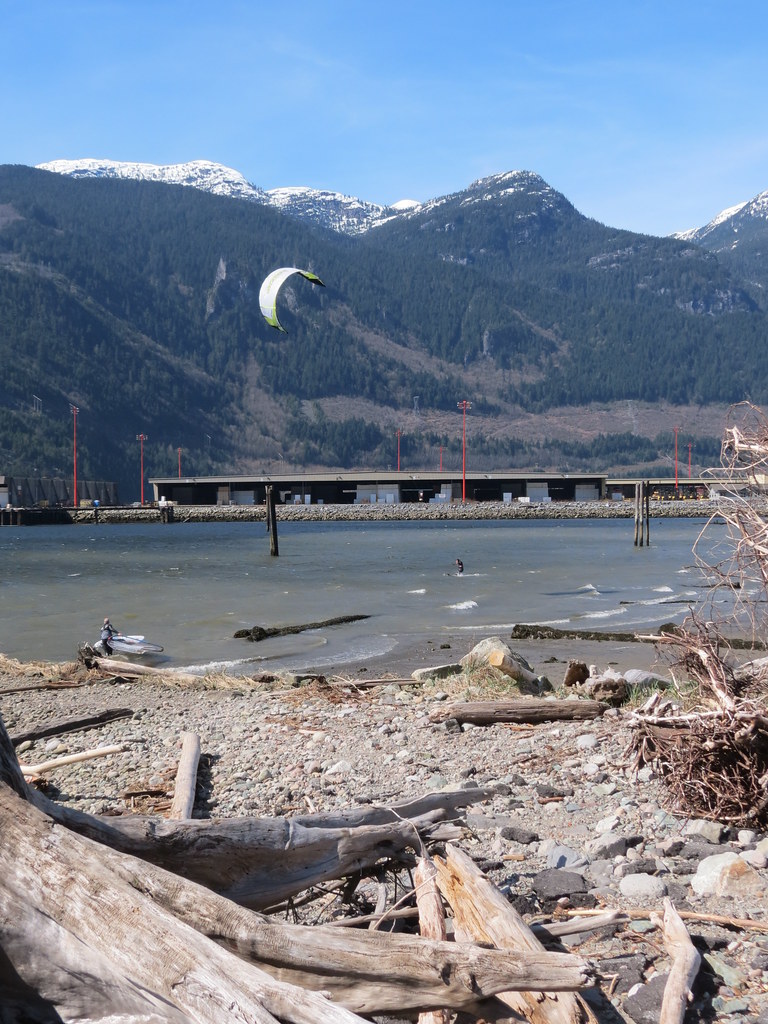
The wind at Nexen is generally similar to that at the Squamish Spit, although Nexen usually gets wind later, has less wind and looses wind first. The exceptions are the days when the wind is strong, shore-to-shore, and/or wind has a lot of west in it (which can favour Nexen). On lighter days its best to head for the Spit. Click here to view the wind data and summary for Squamish Spit.
Direction(s):
- South-southwest through southwest (inflow) wind is the predominant direction as shown by the way the wind-shaped trees grow and there is also some north (outflow) wind - but this direction is not sailed at Nexen as it is straight offshore.
- Wind can arrive later and leave earlier than at the Spit
- On light days, Nexen may not even been sailable, while the Spit (particularly the river) may
- It can be tricky sailing upwind to get out of the cove (as the cove is narrow and there are obstacles like the piles in the cove and off the end of the point).
- Wind shadow from the Squamish Terminal can cause gusty shifty wind in the cove (often worse on the west side of the cove, worse if there is west in the wind, and/or worse if there is a ship moored in there terminal)
- Afternoon thermals – you can work the morning in the city or sleep in and still get a session in!
- Clear blue skies and warm sunshine make for good days
- If Vancouver gets over 25 degree Celsius it can temper the thermal
- In general, clouds/rain are bad (they can cause weak, unsettled conditions) - although a southerly pressure push can produce solid 25 mph days that start early and last all day
- The day after a rain can have a thermal (unlike Nitinaht Lake where the Cowichan Valley needs a few days to dry out after a rain)
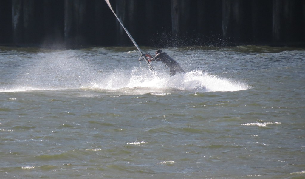
Water conditions at Nexen can range from fairly flat on lighter days to decent rolling bump and jump conditions (knee to waist high rolling wind swell with some steeper faces). Water conditions on the bank out in front of (south of) Nexen and in the cove are often very similar, unless the wind has a lot of west in it and then the wind becomes side-off the terminal causing the cove to remain flatter.

It is possible to sail out into Howe Sound and up to the Spit at the Squamish River from Nexen. Click here to view a description of the water conditions off the Spit, including the sound, the estuary and the river.
Width:
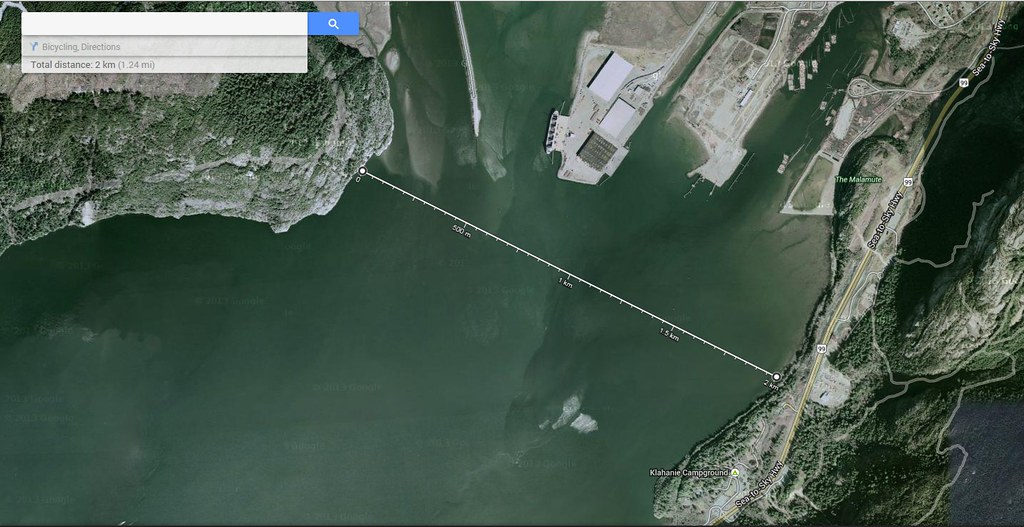
The cove is similar in width to the Squamish River at about 300 m wide by about 150 m from the beach to the open water. The water over the bank to the south of Nexen (between the Squamish Terminal and the east shore of the sound near the Malamute Bluff) is about 1 km wide and 350 m from the mouth of the cove to the open water of the Howe Sound to the south. Beyond the Squamish Terminal and the Spit the Howe Sound opens up to a width of about 2 km.
Depth/Tide:
Nexen provides a great option for those who want a more space to rig and/or want to be able to stand on the bottom of the cove.
It is possible to sail at the Nexen on any tide height, although a short walk across the exposed bank may be required on a low tide.
Nexen is not foil-friendly.
- 0 m – Cove is dry and the beach is exposed to the end of the point - SHORT WALK out to the shallow water for launching
- 1 m – Most of the cove is dry and the beach is fully exposed at the launch at the point – shallow water for launching directly out from the point
- 2 m – About 100’ of beach exposed in the cove – windsurfers can launch and sail at the point
- 3 m – Water in the cove almost all the way up to the edge of the beach in the cove.
- 3.5+ m – Beach in the cove is covered with knee deep water
Sweet Spot(s):
- Shallow protected water in the cove (great place to practice freestyle, beach starts and water starts windsurfing)
- Rolling swell and jumping ramps near where the two ‘cans’ off the harbour entrance used to be (stronger wind and incoming tide help to create these)
- Flat water in the mouth of the Squamish River upwind (to the southwest)
- None
- Winter: 6/5/3 full suit with hood, boots, gloves (unusual to sail here)
- Spring/fall: 5/3 full suit, hoods, boots (unusual to sail here)
- Summer: 4/3 full suit or less
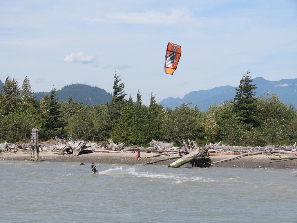
- Sand beach in the cove
- Rocky shoreline on the point
Nexen offers way more space to rig than there is at the Spit.
- Bark mulch area near the slack line park for kites
- Grass rigging area near the point for windsurfers
Launching at Nexen is likely easier than the Spit for windsurfing (no river current and clean wind) but likely harder for kites (on-shore wind, bottom of cove, piles).
- Kites pump up in the area near the slack line park and launch from the beach at the north end of the cove (tether launch is possible off the beach)
 .
.
On high tide it may not be possible to launch from the beach at the north end of the cove (as tempting as it might be, you might not be able walk far enough into the wind prior to launching your board) - if the water is high you may have to walk your board up to the windsurfing launch on the point (marked with a "W" on the site map above), return back to launch your kite near the slack line park and then walk your flying kite up to your board at the point to launch your board. As you are walking your board up to the point make sure to scope a route that you will be able to safely walk your flying kite up to the point. For more details click here.
- Windsurfers rig in the grass area near the point and launch in the cove or at the point


Amenities:
- A real beach
- Easy access to your vehicle (parking lots are close to the rigging areas and launches)
- Porta potty
- Slack line park
- Flat sheltered walking trails (easy walk to downtown)
- There are a range of restaurants and services in Squamish
- Camping is offered at Alice Lake Provincial Park and the Stawamus Chief Provincial Park
- None.
Cautions:

- Kites self-launching and self-landing at the beach in the cove
- Trees and power lines on the east side of the cove
- Submerged logs/debris in the cove
- Piles in the cove
- Rocky shore line at the point
- Piles off the end of the point
- Docks on the south shore (outside the cove)
- Wind shadow from the Squamish Terminal
- Boat/freighter traffic
Tips:
- First time out with windsurfing gear, launch from the cove
- If you are launching windsurfing gear at the point for the first time – walk into the water without your gear first to explore what is the water
- Early spring (Mar, Apr) and late fall sailing (Sep) it can be better to head for the Spit
When to go:
Predicting wind at Squamish is as much an art as it is a science as there are several contributing factors including pressure (infow or outflow), thermal (temperature gradient from Vancouver to Lillooet), and cloud cover. Click here to some tips on what to look for at the Squamish Spit that also apply to Nexen.
Links:
Construction Updates - Oceanfront Squamish
Wind Forecast – Howe Sound
Wind Forecast - WindGURU, Squamish
Wind Forecast -Alton’s Temperature Grid
Tides
Frieghter Schedule
NOAA Satellite
Webcams - Squamish Airport
SWS Wind Sensor
Pictures and Videos
Unless noted otherwise, all pictures used and referenced in this post are by C36 (all rights reserved).
Other Stuff
First Discovered By:
Lore and Legend:
Disclaimer
Every sailor is responsible for sailing safely, including checking local conditions first hand, choosing appropriate gear and sailing within their ability. Have fun, sail safe!
Thanks
Thanks to the District of Squamish for operating this great sailing site. Thanks to Alton, PeterG, Igor, and Rob for sharing their local knowledge.
Updates
If you see anything that should be corrected or you have information that you think should be added, please post it to this thread and we will update the main post. Thanks.
/edit (2015 Mar 4): Caution for kite board launch on high tide added to "Launch" section (thanks Slappy).
/edit (2015 Mar 7): Family-friendly intro added (thanks Craig) and "not foil-friendly added to "Depth/Tide" section (thanks Slappy)
/edit (2015 May 24) status of the two cans updated under "Sweet Spots" (no longer there)
/edit (2021 May 10) link to construction updates added

