2019 first sesh Thursday? Wednesday too cold
32 posts
• Page 1 of 4 • 1, 2, 3, 4
-

LeopardSkin - Posts: 2729
- Joined: Mon Oct 21, 2013 8:01 am
- Location: on my phone
Currently looking like SE Thursday and SW Friday.
- igetwind_boundary-bay-3rd-avenue.png (45.5 KiB) Viewed 11430 times
-

Alton - Posts: 7065
- Joined: Mon Oct 21, 2013 6:09 am
Still looking good. Hoping for Thursday morning so I can rest up for Friday morning 
- igetwind_boundary-bay-3rd-avenue.png (43.15 KiB) Viewed 11273 times
-
Alton - Posts: 7065
- Joined: Mon Oct 21, 2013 6:09 am
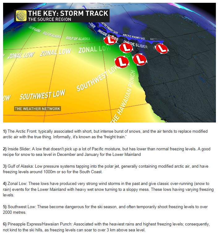
M: This is the article I mentioned on path of the low pressure systems. But contrary to what I said from memory, it is the "Zonal Low" (straight approach in from the west) that have produced very strong wind storms in the past (according to WN). Sorry for the delay in posting.
The path for Thursday's low look more like a "Southwest" Low (warmer).
You can view the full-size screen shot here.
-

C36 - Posts: 2190
- Joined: Fri Oct 25, 2013 8:17 pm
C36 wrote:M: This is the article I mentioned on path of the low pressure systems.
Thanks Dave, things are still looking good for tomorrow!
- Attachments
-
- Screen Shot 2019-01-02 at 4.34.14 PM.png (89.64 KiB) Viewed 11189 times
- Michael
- Posts: 2773
- Joined: Mon Oct 21, 2013 9:31 pm
C36 wrote:M: This is the article I mentioned on path of the low pressure systems.
Michael wrote:Thanks Dave, things are still looking good for tomorrow!
I think so too. I went back and looked at the last small gear days sailed at CNL in the last two seasons and five out of six (or over 80%) were "Southwest" lows (that may have been why I made the slip).
It's also worth noting that five of those were in 2017.
When I get a chance I'll take a look at the other examples further back.
-
C36 - Posts: 2190
- Joined: Fri Oct 25, 2013 8:17 pm
100% Dave. That SW track where the centre of the low crosses mid to southern Van Isle and then keeps moving NE is the one to watch for the Lower Mainland. The American meteorologists actually call it a “Southeast Sucker.”
If the low crosses south of us we get a cold NE/E day and the wind direction never switches. If the low crosses straight overhead the wind direction and strength is usually all over the place. If the low passes just north of us we are normally golden. A stalled warm front or “lifted”warm front usually spells a day of easterly winds and steady rain at Centennial.
I always like to see a strong cold front, occluded front or bent back occlusion mentioned in the forecast discussion. It’s pretty rare to get big SE winds on a warm front. The ideal setup is a quickly deepening low where the warm front slows and cold front accelerates to join up into a bent back occluded front. These are the ones that usually unleash the big SE winds when the central pressure of the low is deep enough and the occluded front swings across the Lower Mainland.
For central pressures anything below 985mb is great if it stays on that SW / NE track. Alton’s site is so good with all the links and real time weather info. Sure beats the plexiglass over a marine chart and a dry erase marker we used to use 20 years ago to chart the pressures as the low approached.
Just like you, I always kept a windsurfing journal with the low track, forecast, actual conditions and every bit of info I could remember for the day when I used to winter sail in Vancouver. It really helped to recognize patterns and potential for the good days and limit the skunks.
Happy New Year........
Cheers,
Chris
- Chris Klohn
- Posts: 1148
- Joined: Fri Nov 01, 2013 1:49 am
Thanks Chris ... but I didn't understand anything you said.
Looking like a good start. Hope it lasts and remains civilized.
Looking like a good start. Hope it lasts and remains civilized.
- Boundary_Bay_Thu_Jan_3.gif (15.34 KiB) Viewed 11101 times
-
Alton - Posts: 7065
- Joined: Mon Oct 21, 2013 6:09 am
Thanks for chiming in Chris. I find it interesting to get the "hindsight' explanation but have a poor understanding of the forecasting. Thus I look for lots of models saying the same thing. When things are good enough to get Chris's attention, it's another really good sign.
To my eye, this looks like one that even I couldn't mess up. Aiming to squeeze in a morning session as have to make it work around work.
To my eye, this looks like one that even I couldn't mess up. Aiming to squeeze in a morning session as have to make it work around work.
- Mike
- Posts: 831
- Joined: Sat Nov 02, 2013 8:30 am
1.5 hrs over powered on 7m in SSE 26 g 33. Sweet chest high waves. Taking a desperately needed break.
-
Alton - Posts: 7065
- Joined: Mon Oct 21, 2013 6:09 am
32 posts
• Page 1 of 4 • 1, 2, 3, 4